


Satellites and drones could be drafted in to help save the bumble bee.
The “eyes in the sky” can provide key information to protect threatened pollinators, say scientists.
Their study examines new ways of using state of the art technology to track the availability of flowers.
They say it could be combined with behavioural studies to see the world through the eyes of insects.


The flowers available to insects vary from day to day and place to place, and human activity is changing landscapes in ways that affect all pollinators.
The University of Exeter research team, supported by the South Devon Area of Outstanding Natural Beauty (AONB), hope the new approach can help scientists to understand the changes, leading to better conservation.
Lead author Dunia Gonzales, a PhD student at the University of Exeter researching spatial learning in bees, said: “Recent advances in drone and satellite technology have created new opportunities.
“Drones can now give us fine details of a landscape – on the scale of individual flowers – and combining this with satellite imagery, we can learn about the food available to pollinators across a large area.
“Along with behavioural studies of insects, this will help us understand the threats they face and how to design conservation programmes.
“With some pollinator species in decline, including many wild bees, we urgently need this understanding to protect not just pollinators in general but also the great diversity of species that each play vital roles in complex ecosystems.”
She said pollinators provide a range of benefits - called ecosystem services - especially to humans by pollinating food crops.
However, much about their behaviour and habitats – and the impact of climate and habitat change caused by humans – remains unknown.
Ms Gonzales said: “Up to now, most research using satellites has focussed on large-scale agricultural landscapes such as oilseed rape, maize and almond farms.
“We highlight the need to study landscapes with complex communities of plants and pollinators.
“These vary from place to place – and using satellites and drones together is a good way to learn about these local differences.
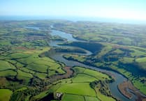
“For example, the South Devon AONB contains many smaller fields, microhabitats and traditional Devon hedgerows – so effective conservation here might be different from the measures that would work elsewhere.”
The findings were published in the journal Frontiers in Ecology and Evolution.
Comments
This article has no comments yet. Be the first to leave a comment.